 |
 |
MOVING
ALONG THE STREAM CORRIDOR:
A LONGITUDINAL VIEW
Structural
Changes in the Stream Corridor from
its Headwaters to Outlet
The physical structure of the channel and floodplain changes as a river travels from its headwaters to its outlet. Channel width and depth increase downstream as the drainage area and discharge increase. A simplified longitudinal model captures these observed changes by disaggregating the river into three zones: headwaters zone, transfer zone, and depositional zone (Figure 1.2). The headwaters zone generally has the steepest slope. As the water moves over these slopes, sediment erodes and is carried downstream. In the transfer zone, which receives sediment from upstream, the gradient decreases. The river widens as smaller streams merge. In the depositional zone, the gradient flattens from a build-up of sediment over time. The river widens further and meanders toward its mouth.
These same three zones are also evident on a much smaller scale within the watersheds of contributing streams. A watershed is defined as the area of land that drains water, sediment, and dissolved materials to a common outlet at some point along a stream channel (Dunne and Leopold, 1978). The size and structure of watersheds vary significantly due to geologic, morphologic, vegetative, soil and climatic differences. Differences in topographic and geologic structure also influence watershed drainage patterns.
Stream Order Models
As water moves along pathways of least resistance in the watershed, it forms streams that join larger and yet larger streams. The resulting river is branched like a tree; the particular form of the branching depends on the watershed through which the water flows. A method of classifying the hierarchy of natural channels according to their position in the drainage system, referred to as stream order, permits comparison of the behavior of a river with others similarly situated. It is useful for developing and testing generalizations and predictions about river processes. Several modifications exist of the original stream-order system developed by Horton in 1945. In the most commonly cited and used system (Strahler, 1957), small headwater streams are designated Order I. Streams formed by the confluence of two Order I streams are referred to as Order II, and so on, with larger numbers indicating larger rivers with multiple tributary streams (Figure 1.3). Stream order is used primarily by hydrologists to construct models of stream flow. Stream order correlates generally with gradient, drainage area, channel width, and discharge; but because of multiple intervening factors, the statistical variance of the correlations is large.
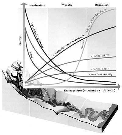
Figure 1.2 The Three Longitudinal Zones and Channel Characteristics. Reprinted with permission of Federal Interagency Stream Restoration Working Group (1998).
Longitudinal Changes in Stream Ecosystems
Beyond structural changes in the stream channel, there are observable changes in stream ecosystems from the headwaters to the mouth. The characteristics of biological communities vary in different reaches of a river system. Observation of abrupt changes in species associated with changes in stream size, channel width, gradient, stream flow and temperature supports the concept of stream zones, as described above.
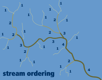
Figure 1.3 Stream Order Classification. By permission, Ojakangas, Richard W. 1982. Minnesotas Geology. With Charles L. Matsch. Drawings, charts, and graphs by Dan Beedy. Minneapolis : University of Minnesota Press. p. 114.
The best known longitudinal model for rivers, the River Continuum Concept (RCC), attempts to generalize and explain observed longitudinal changes in stream ecosystems (Figure 1.4). It proposes that rivers exhibit continuous longitudinal changes and identifies the relationships between the progressive changes in stream structure, such as channel size and stream flow, and the distribution of species (Table 1.1). According to the RCC, characteristics of particular reaches are associated not only with discrete factors such as water temperature, but with their positions along the length of the river. The model is especially useful at the basin and stream scale, because it accounts for observed longitudinal shifts in biotic communities.
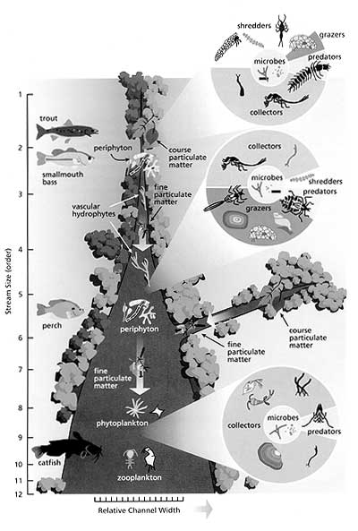
Figure 1.4 River Continuum Concept. Reprinted with permission of the Federal Interagency Stream Restoration Working Group (1998).
The RCC as originally defined was most successful in describing rivers that emerge in forested mountains and descend into regulated channels on the floodplain. Since its initial development, the RCC has been expanded to include several alternative models. Rivers that regularly overtop their banks and inundate the floodplain have been characterized by a Flood Pulse model that describes habitat characteristics and biotic communities along a temporal continuum. A temporal dimension is embedded in the RCC because the main features of a time-based river model (e.g., duration of inundation) vary longitudinally in a predictable fashion.
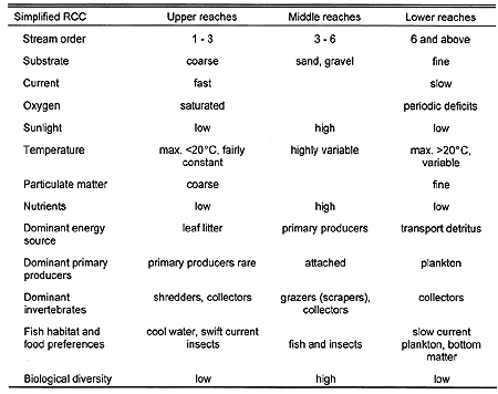
Table 1.1 Commonly Observed Changes Associated with River Continuum Concept. Adapted from Ward. 1992. A Mountain River, Chapter 23 in River Handbook, P. Calow and G.E. Petts, eds. pp. 499.
An alternative model adopted by some ecologists is referred to as patch dynamics. According to this model, stream habitat and species distribution exhibit patchiness. Stream communities are not determined by the nature of a given zone or stream reach but are viewed as random phenomena (Townsend, 1989). The patch dynamics concept reflects relatively short-term observations on a stream-reach scale at which the nature and distribution of biotic communities appear unpredictable. It is complementary with the RCC because most running waters that show local patch effects will exhibit predictable longitudinal patterns over larger scales and longer time periods (Brezonik, 1996).