 |
 |
WHO
CONTROLS MINNESOTAS RIVERS?
POLICY, PLANNING, AND MANAGEMENT
INTRODUCTION
This chapter provides an introduction to policy, planning and management activities related to Minnesotas rivers. Policy and planning efforts occur at state, regional and local levels. The management of Minnesotas water resources is highly dispersed. A conglomeration of federal, state, and local agencies manages different river functions. The role of various agencies and their management activities are explored in this chapter.
POLICY AND PLANNING
Statewide Policy and Planning
The Minnesota Environmental Quality Board (EQB) develops statewide policy and engages in planning activities relating to environmental issues affecting rivers and watersheds. The EQB also plays a role in resolving conflicts among state agencies with regard to programs, rules, permits, and procedures significantly affecting the environment. Under the Minnesota Environmental Policy Act, the EQB retains the authority to request an environmental review for certain projects affecting the states rivers and watersheds. The EQB consists of representatives from ten state agencies and the governors office and five individuals from the general public. The ten participating state agencies are the Departments of Agriculture, Health, Natural Resources (DNR), Commerce, Trade and Economic Development and Transportation; Pollution Control Agency (PCA); Board of Water and Soil Resources (BWSR); Minnesota Planning; and the Office of Environmental Assistance. A small professional staff supports EQB activities.
If implementation of EQB policy decisions requires changes in state laws, BWSR, in conjunction with DNR and PCA commissioners, recommends such changes to the legislature. When questions arise regarding specific water policy issues, the governor, state or federal agencies, district court judges or affected individuals may assert the right to petition the BWSR to intervene. If the BWSR agrees to intervene, it conducts a public hearing and makes recommendations based on evidence presented at the hearing.
In addition to statewide activities, Minnesota participates in interstate planning and policy related to the Upper Mississippi and the St. Croix rivers. The Upper Mississippi River Basin Association, with members representing Minnesota, Iowa, Illinois, Missouri, and Wisconsin, coordinates policy development, planning, and implementation on issues related to use of the Upper Mississippi River system. The Association also commissions and conducts studies on common water resource concerns. Minnesota state law also addresses several policy, planning, and management activities related specifically to wild and scenic rivers, floodplains, and shoreline. These laws include the Minnesota Wild and Scenic Rivers Act of 1990, The Minnesota Floodplain Management Act of 1969, and the Shoreline Management Act of 1969.
Minnesotas Wild and Scenic Rivers Act. Minnesotas Wild and Scenic Rivers Act, provides statutory protection for rivers and adjacent lands that possess outstanding scenic, recreational, natural, historical and scientific attributes. River areas protected by the Act fall into three classifications: wild, scenic or recreational. Rivers designated as wild flow freely through primitive adjacent lands. These rivers generally exhibit excellent water quality. Rivers receiving protection under the scenic category flow freely through predominately undeveloped adjacent lands, while rivers designated as recreational may flow through relatively developed adjacent lands. Classification of a river as recreational does not require the river to be free-flowing. Recreational channels may include modifications such as dams and diversions and receive protection under the Act.
The Minnesota DNR administers Minnesotas wild and scenic rivers system program. DNRs responsibilities include identifying and proposing rivers for wild and scenic designation, establishing a management plan, and specifying minimum standards. All aspects of use and development of protected rivers and adjacent lands become regulated. Ownership influences management activities on lands adjacent to protected areas of a river. On public lands, the state retains the administrative authority to ensure that management activities remain consistent with the management plan. On private lands, local governments facilitate protection and preservation goals through zoning ordinances. These ordinances must meet the minimum management standards specified by the DNR. The Wild and Scenic Rivers Act requires local governments to ... preserve and protect, reduce the effects of overcrowding and poorly planned development, to prevent pollution, to provide space for sanitary facilities, to preserve natural beauty and quietude, and to maintain property values, and promote the general welfare (Minn. Rules 6105.0080).1 In addition, the DNR has the authority to approve variances granted by local governments.
Watercourses designated as State Wild and Scenic Rivers under Minnesota law include portions of the Mississippi, Minnesota, St. Croix, Crow, Rum, Kettle and Cannon rivers (see Table 4.1 and Figure 4.1).
In 1968, when the United States Congress approved the National Wild and Scenic Rivers System, it designated the St. Croix River as one of the eight rivers initially protected under the Act. The protected portion of the river runs from its headwaters in Wisconsin to Taylors Falls. In 1972, the protected area was expanded to include the Lower St. Croix from Taylors Falls to the Mississippi. This scenic river is managed according to the federal Wild and Scenic Rivers Act, the federal Lower St. Croix Act and the Lower St. Croix National Scenic Riverway
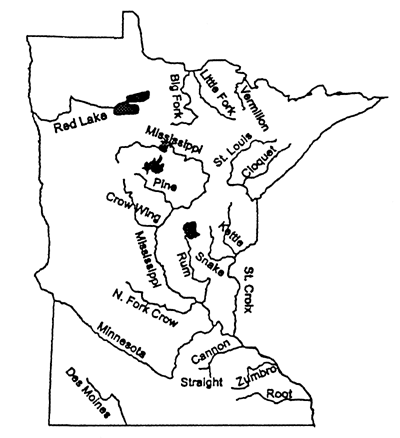
Figure 4.1 Minnesotas Wild, Scenic and Recreational Rivers and Lower St. Croix National Scenic Rivers. Minnesota Dept. of Natural Resources, Division of Waters and Trailways.
Table 4.1 Protected River Areas in Minnesota
| River | Protected Area |
| Mississippi | from St. Cloud to the city of Champlin |
| Minnesota | from Lac Qui Parle Dam to near the city of Franklin |
| St. Croix | from the Wisconsin border to the Mississippi |
| Crow | north fork portion of the river in Meeker County |
| Rum | from Ogechie Lake to the city of Anoka |
| Kettle | in Pine County |
| Cannon | from the city of Faribault to the Mississippi |
Cooperative Management Plan. The state of Minnesota recognized and concurred with the designated federal protection status. The Minnesota and Wisconsin DNRs provide administrative leadership and operate in partnership with the National Park Service and local governmental units. To date, the St. Croix remains the only Minnesota river among the 212 U.S. rivers on the federal Wild and Scenic Rivers list.
Floodplain Management Act. Floodplains receive floodwaters and the sediment they carry when stream channels overflow. Minnesotas Floodplain Management Act of 1969 provides the State authority to regulate land uses on floodplains to minimize potential flood damage. The Act requires the DNR, in conjunction with other state agencies, to map floodplains, determine the probability of different flooding scenarios, identify measures to mitigate against flood damage and enforce compliance among local governments responsible for adopting local floodplain zoning ordinances.
The sizes of floodplains vary both along river systems and among river systems. Depending on surrounding topography, the floodplain may include land on one or both sides of the channel, and the area may vary considerably along a river. Mapping a floodplain involves identifying the land area covered by flood waters under various flooding scenarios. For planning and management purposes, the outer perimeter of the floodplain is determined by the worst possible flood that would occur (on average) over a 100-year period. Historical data, provided by the Natural Resources Conservation Service (NRCS) and the Army Corps of Engineers, are used to estimate this 100-year event. Floodplain mapping includes delineation of the floodway and flood fringe. The floodway, the land immediately adjacent to the stream channel, provides a natural conduit for flood waters. During flooding, it becomes part of the river, carrying much of the floodwater downstream. The flood fringe extends from the outer border of the floodway to the edge of the floodplain. Shallow, slow-moving flood water covers this area during a 100-year flood event.
When data availability permits development of floodplain maps, local communities must adopt floodplain zoning ordinances. These zoning ordinances include management rules and guidelines established by the DNR, which retains responsibility for enforcing compliance by local governments. These rules and guidelines strongly encourage the use of non-structural protection mechanisms in lieu of levees, dikes and dams. Floodplain management rules also specify the type of development allowed on the floodway and flood fringe. For example, to ensure unobstructed flow of flood waters, management rules permit only open land uses with low flood vulnerability, such as agriculture or parks. On the flood fringe, proposed structures must comply with flood protection elevation, flood proofing construction codes and other applicable ordinances.
The National Flood Insurance Program requires flood insurance policies on new structures in floodplain areas recognized by the Federal Emergency Management Agency (FEMA) prior to granting loans. FEMA, the agency responsible for administering federal flood relief programs, maintains a data base on lands vulnerable to flooding in the United States.
Shoreland Management Act. In 1969, the Minnesota State Legislature passed the Shoreland Management Act to ensure preservation and wise development of land bordering lakes and rivers. The DNR Division of Waters, Land Use Management Section, administers the Shoreland Management Program. The Act defines river shorelands as land within 300 feet of a public watercourse or the landward extent of the delineated floodplain, whichever is greater. The DNR classified the states public waters for allowable intensity of shoreland development. These classifications are remote, forested, transition, agricultural, urban, and tributary. For each classification, the DNR developed minimum standards for land uses, structure placement, lot sizes, shoreland alterations, and construction of sanitary facilities. Counties and municipalities with shoreland areas covered by the Act, must adopt and enforce shoreland zoning ordinances that meet or exceed the minimum standards developed by the DNR. To assist localities with the development of appropriate ordinances, the DNR developed a Model Shoreland Ordinance. The DNR reviews local ordinances to ensure that the minimum standards are met. If a county or municipality fails to adopt a satisfactory ordinance, the DNR retains the authority to require adoption and implementation of the Model Shoreland Ordinance. As of March 1996, approximately 170 cities and 85 counties in Minnesota had implemented shoreland zoning ordinances.
Regional Policy and Planning
In Minnesota, many organizations and agencies play a role in regional policy and planning activities related to streams and rivers. Given space constraints, this section describes only a few of these organizations and agencies.
Under state law, two or more local governmental units can form a regional river basin joint powers organization if each unit agrees to work cooperatively with the other member units to protect, preserve or enhance an identified river resource. Some of the current joint powers organizations include: the Red River Watershed Management Board, Area II Minnesota River Basin Projects, Inc., Redwood-Cottonwood Rivers Control Area, Upper North Branch Root River Watershed, Whitewater Joint Powers Board, Minnesota River Joint Powers Board, Southeastern Water Resources Board, and Mississippi Headwaters Board.
The Mississippi Headwaters Board (MHB) is a well-established regional river basin joint powers organization. The Board maintains responsibility for protecting the natural, cultural, scenic, scientific, and recreational values of the first 400 miles of the Mississippi River. The MHB includes representatives from the eight headwaters counties: Aitkin, Beltrami, Cass, Clearwater, Crow Wing, Hubbard, Itasca, and Morrison.
In 1967, the state legislature authorized the creation of the Metropolitan Council as a regional planning authority for the Twin Cities Metropolitan Area. The Council coordinates planning and development of major systems in Minneapolis, St. Paul and their surrounding communities. Its areas of responsibility include water quality protection and river corridor development. The Councils Environmental Services division, which owns and operates the regional sewage system, assists with implementation of water quality protection policies. For river corridor development, the Council works with developers and local governments to implement its policies.
Local Water Policy and Planning
Most Minnesota communities participate in water policy and planning activities that affect local water resources. This section focuses on four key pieces of legislation designed to facilitate community involvement in local water policy and planning activities in Minnesota: Soil and Water Conservation Law, Minnesota Watershed Act, Metropolitan Surface Water Management Act, and the Comprehensive Local Water Management Act. In 1987, the state legislature authorized the Board of Water and Soil Resources (BWSR) to provide oversight for local activities related to these laws. Prior to 1987, oversight responsibilities were shared by three independent entities: the Soil and Water Conservation Board, Southern Minnesota Rivers Basin Advisory Council, and the Water Resources Board.
Soil and Water Conservation Law. The Soil and Water Conservation Law authorized the creation of Soil and Water Conservation Districts (SWCDs). SWCDs encourage land owners and tenants to implement management practices to preserve natural resources, protect soil productivity, and control flooding. Management practices tend to emphasize prevention and reduction of soil erosion, sedimentation, and nonpoint pollution. Ninety-one SWCDs presently operate in Minnesota.
Minnesota Watershed Act. Managing natural resources by watershed allows an integrated, holistic approach to resource conservation. The Minnesota Watershed Act provides a means for local governments to engage in cooperative planning and policy activities on a watershed basis to solve and prevent local water-related problems. The Act gives county boards, city councils, or landowners within one or more watersheds the right to petition the BWSR to establish a watershed district. Watershed districts are authorized to construct projects, identify and assess properties that benefit, levy taxes, acquire property by eminent domain, and regulate activities that affect the districts objectives. Forty-two watershed districts currently exist in Minnesota.
Metropolitan Surface Water Management Act. The Metropolitan Surface Water Management Act requires the development and implementation of watershed management plans by Watershed Management Organizations (WMOs) within the seven-county Twin Cities Metropolitan Area. The Act further requires that each city or township in the Metropolitan Area develop and administer its own plan. To ensure the plans all work together to protect local watersheds, each city or township must demonstrate that its plan is consistent with all other plans in the affected watersheds. The DNR, PCA, Department of Health, and Metropolitan Council must review and approve each city and township plan before it receives final approval by the BWSR. There are 38 WMOs in the Metropolitan Area. Thirteen are organized as watershed districts, 23 are organized based on joint powers agreements and two are county operated WMOs. Joint powers agreements are agreements made among affected units of government.
Comprehensive Local Water Management Act. The Comprehensive Local Water Management Act encourages Minnesota counties outside the Twin Cities Metropolitan Area to develop and implement comprehensive water plans. Comprehensive plans must cover the entire county and conform with any existing plans enacted by watershed districts within the county. Comprehensive plans must also address existing local, city or township plans. However, once a comprehensive plan for the county receives approval, local plans conform with it. The BWSR reviews plans for conformance with state laws and regulations and resolves disputes over the interpretation of plans that may arise between and among the various units of local government. All 80 counties currently have comprehensive water plans and revise them every five years.
MANAGEMENT OF MINNESOTAS RIVERS
River management in Minnesota is dispersed. A variety of federal, state, and local agencies is involved with different management activities (Table 4.2). Key management agencies include: U.S. Army Corps of Engineers, U.S. EPA, Minnesota DNR, Minnesota PCA, Minnesota EQB, BSWR, and the Metropolitan Council. Counties, watershed districts, and soil and water conservation districts also have important river management roles. Some management functions are performed primarily by a single agency. For example, navigation on the Upper Mississippi River system is controlled by the U.S. Army Corps of Engineers, and the DNR has sole responsibility for issuing water withdrawal permits. Some functions are shared by federal and state agencies. The Army Corps of Engineers and the DNR both regulate alterations to river channels; the EPA and PCA have complementary roles protecting water quality. Some functions, however, are dispersed among many jurisdictions, which has led to interjurisdictional conflicts, multiple interpretations of rules, and patchy management success. This section focuses on river management activities in Minnesota and the agencies responsible for administering them. Appendix B contains a listing of each agencys address and telephone number.