 |
 |
INSTREAM USES
Instream uses depend upon the water in the stream channel. These uses often require alteration, stabilization, or protection of the channel itself to create desired flow conditions. Measuring instream uses raises complex issues. Unlike offstream uses, for which the quantity of water withdrawn provides a measure of the level of use, instream uses can be measured in many different ways. In addition, the extent of in situ use, such as for fish and wildlife habit, is extremely difficult to quantify. Instream uses, such as hydropower and commercial fishing, may generate revenue for the user or provide other non-market related values, such as protecting endangered species. This section identifies and describes major instream uses of Minnesota’s streams and rivers.
Hydropower
Minnesota’s rivers have 32 active hydropower dams with a combined electrical capacity of about 215 megawatts, about 2 percent of the state’s total electricity production. The State of Minnesota and the Federal Energy Regulatory Commission (FERC) regulate all hydropower dams (DNR, 1995). Most generate power for profit; only six use the power directly for manufacturing. Minnesota Power Company owns and operates the largest hydropower plant in the State with a capacity of 72.6 megawatts. Otter Tail Power Company owns the smallest hydropower plant with a 0.4-megawatt capacity.
Commercial Navigation
Approximately 230 miles of river in Minnesota are designated as navigable riverways for commercial vessels and belong to the national Shallow Draft Navigation System. This system consists of 22,000 miles of river channel across the United States. The Mississippi River contains 80 percent of navigable channels and terminals, and the St. Croix and Minnesota Rivers each have 10 percent (Table 3.3).
| River |
Miles
of channel
|
#
of Terminals
|
|
|
Grain
|
Other
|
||
| Mississippii |
183.8
|
15
|
33
|
| Minnesota |
21.8
|
4
|
6
|
| St. Croix |
24.5
|
0
|
3
|
| Total |
230.1
|
19
|
41
|
Table 3.3 Miles of Channel and Terminals on Upper Mississippi River System in Minnesota
The Army Corps of Engineers maintains channel conditions and related lock and dam facilities. They dredge channels along the upper river system in Minnesota to ensure a depth of at least nine feet. A fully loaded barge requires a minimum depth of nine feet to maneuver safely in the channel. Regular dredging keeps the channels open in areas where fast moving tributaries discharge into the main river and deposit large amounts of sediment. The Corps also operates the lock and dam facilities that lift and lower river vessels. The locks in Minnesota were designed and built to accommodate barges up to 290 feet long with a 50-foot width and a maximum cargo-carrying capacity of 3,000 tons.
Commercial navigation includes both freight and passenger traffic. Freight traffic generates significant economic returns to the state. A substantial amount of freight moves through Minnesota’s 58 active river terminals, including: grain, coal, liquid and dry fertilizer, iron and steel, sand and gravel, crude oil and petroleum products, newsprint, and all types of heavy general cargo.
Historically, grain constituted at least one half of annual freight tonnage. Over 60 percent of Minnesota’s grain exports are shipped by river (MDOT, 1993). In addition, grain shipments from North and South Dakota, western Wisconsin, and northern Iowa move through Minnesota’s river terminals. Between 1972 and 1992, these terminals handled an average of 11 percent of the grain exported from Gulf Coast terminal or roughly 7 percent of total annual grain exports from the United States (MDOT, 1993). Commercial passenger use of the state’s riverways is relatively limited compared with freight traffic. Passenger traffic includes both large cruise and local excursion boats. Large cruise boats make occasional visits to the city of St. Paul in the summer months. For example, in 1992 seven cruise boats docked near downtown St. Paul. Each cruise boat visit generates an estimated $500,000 in revenue to the city. Many excursion boats carry passengers on trips of one day or less. A total of 17 vessels holds the required U.S. Coast Guard certification to carry passengers. Active passenger terminals on the Mississippi River are located in Minneapolis, St. Paul, Red Wing, Lake City, and Winona. Active passenger terminals on the St. Croix are located in Afton, Bayport, Stillwater, and Taylors Falls. The only active terminal on the Minnesota River is in Shakopee. Excursion boats carry nearly a quarter of a million passengers each season in Minnesota. For example, the Paddleford Pacquet Company in St. Paul carries more than 100,000 passengers annually, over half of whom reside outside the metropolitan area (MDOT, 1993).
Commercial Fishing and Trapping
Commercial fishing and trapping activities depend upon Minnesota’s river resources. Commercial fish harvested from Minnesota rivers include: carp, sucker, sheepshead, and other varieties of non-game (rough) fish from the upper river. The St. Paul District generates about $720,000 annually from commercially caught fish. Other commercial fishing activity on the Upper Mississippi River includes minnow and turtle trapping. Minnesota has long been a major supplier of turtle meat.
Commercial clamming produces shells for export to the Asian cultured pearl industry. This industry finds Minnesota clamshells desirable because of their unique color and luminescence. In 1990, shells harvested from the Otter Tail River in west central Minnesota were valued at between $30,000 and $40,000 (Tester, 1995). Minnesota and Wisconsin limit clam harvests to help protect the resource. Since 1991, all Minnesota rivers except the Mississippi below Red Wing have been closed to commercial shell harvesting.
Minnesota’s commercial trapping activity remains limited. Trappers seek out raccoon, muskrat, mink, and beaver on backwaters and tributary streams. In 1992, furs taken on the navigable portion of the state’s rivers were valued at an estimated $2 million (MDOT, 1993).
Recreational Boating
Recreational boating constitutes one of the largest uses of Minnesota’s rivers. Many Minnesotans consider boating access to the state’s rivers to be a basic right. The state contains 2,850 miles of designated canoe and boating river with some 2,300 state-maintained public access ramps and drop-in points (Figure 3.1).
In 1992, small recreational boats made up almost 50 percent of the traffic in locks on the river navigation system operated by the U.S. Army Corps of Engineers in Minnesota. The boats range in size from canoes to speedboats to houseboats. The Minnesota DNR provides 22 public boat launching ramps on the navigable portions of the Minnesota, St. Croix, and Mississippi rivers. The U.S. Army Corps of Engineers, the U.S. Fish & Wildlife Service and the Minnesota Department of Transportation maintain 15 ramps, and another 74 are owned and operated by commercial businesses, towns, sports organizations, churches, and other non-profit groups. In addition, the Minnesota portion of the Mississippi River contains 104 private boat launches and canoe drop-in sites. Numerous marinas for large recreational boats also exist. They range in size from as few as six boat slips to as many as 600. Forty-eight boat rental operations and 21 private yacht clubs further contribute to recreational boating traffic on Minnesota’s rivers.
Other Recreational Uses
Minnesota’s streams and rivers provide many other recreational uses such as fishing, hunting and wildlife viewing. According to a 1996 U.S. Department of Interior Fish and Wildlife Service survey, people spent an estimated 27,002,000 person-days fishing on Minnesota’s lakes and rivers (U.S. Dept. of Interior, 1997). Anglers spent an estimated $69 per person-day on average for fishing-related travel, equipment and other expenditures in 19962. In the same year, wildlife watchers engaged in 6,807,000 person-days of wildlife watching and spent an estimated $53 per person-day for equipment, food, lodging, transportation and other travel-related costs (U.S. Dept. of Interior, 1997).
Figure 3.1 Minnesota’s Designated Canoeing and Boating Streams. Minnesota Dept. of Natural Resources, Division of Trail and Waterways.
In Minnesota as a whole, hunters spent 6,984,000 person-days and an average of $258 per person-day for equipment, food, lodging, transportation, and other trip costs associated with hunting in 1996. River-bottom lands associated with the Upper Mississippi River system provide over 185 thousand acres of hunting area for upland birds, small game, and deer. Hunters spend an average of 350,000 person-days each year in the Mississippi River-bottom forests. In addition, duck hunters spend over 275,000 person-days on the water (U.S. Fish and Wildlife Service, 1997). Clearly, recreational use of water resources contributes significantly to the state as well as local economies.
Natural Amenity Uses
Non-game wildlife.
The navigable portion of the Upper Mississippi River in Minnesota contains thousands of acres of state and federally managed fish and wildlife areas. Besides protecting habitat, these areas provide recreational services. For example, the Upper Mississippi River National Fish and Wildlife Refuge, which contains 32,900 acres and extends from Wabasha, Minnesota to Rock Island, Illinois, has the largest annual public use of any fish and wildlife refuge in the national refuge system. In Minnesota, 685,000 acres of refuge and park land fall under the auspices of the state. In some refuges, management plans encourage regulated hunting, fishing, and camping activities. In others, management plans prohibit human activity (at least seasonally) to achieve species protection objectives.
Species preservation. Several species designated as endangered or threatened on state and federal lists depend on river habitats for survival. Table 3.4 lists river-dwelling vertebrate animal species on the state’s endangered and threatened list that depend on river habitats. The state list also includes 25 endangered and threatened species of mollusk and one endangered species of the caddis fly. Minnesota’s threatened and endangered river plants include floating marsh marigold, sweet-smelling Indian plantain, kitten-tails, glade mallow, and the dwarf trout lily, which is native only to southeast Minnesota and appears on the federal endangered species list.
Waste disposal
Sewage disposal systems use rivers to dilute treated effluent and move it downstream. Figure 3.2 shows major wastewater treatment plants that discharge into Minnesota’s rivers. Most cities located along a river depend on river water dilution for at least part of their disposal requirements. For example, the Twin Cities’ Metropolitan Plant discharges treated wastewater into the Mississippi River with about 3 parts per million (ppm) phosphorus. A study conducted for the Plant in 1992 concluded that reducing phosphorus discharge from 3 ppm to 1 ppm would cost $180 million in capital costs and add $20 million annually to operating costs. The plant currently avoids these costs by relying on the Mississippi for phosphorus dilution.
| Species | Status | Habitat |
| Northern Cricket Frog | Endangered | Small, pebbly streams in grasslands and near marshes and ponds |
| Massasauga (snake) | Endangered | River bottom lands |
| Paddlefish | Threatened | Open water of large rivers, river lakes, and backwaters |
| Wood Turtle | Threatened | Small, fast-moving, clear-water streams with hard bottoms (sand, gravel, or rock) grassy margins, and elevated sandbars for nesting, in relatively undisturbed areas in forests |
| Blandings Turtle | Threatened | Calm, shallow water with rich, aquatic vegetation, and sandy uplands for nesting |
| Bald Eagle | Federal: Threatened | Lakes and rivers in forested areas with large trees |
Source: Information from Coffin and Pfannmuller, eds. (1988) Minnesota’s Endangered Flora and Fauna and DNR. 1996. Minnesota’s List of Endangered, Threatened and Special Concern Species (Effective 7/1/96) Natural Heritage and Non-Game Research Program.
Table 3.4 Minnesota’s Endangered and Threatened Vertebrate Animal Species Dependent upon River Habitat
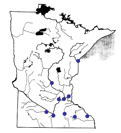
Figure 3.2 Wastewater Treatment Plants Processing More than 5 mgd.
Footnote 2
Average estimated based on total angler expenditures of $1,874,835,000 divided by 27,002,000 angler days for the State of Minnesota (U.S. Department of Interior, 1997).