 |
 |
HYDROLOGIC CYCLE and STREAM FLOW
Water inputs into Minnesotas streams and rivers come primarily from runoff associated with precipitation. The majority of the states annual precipitation (65 to 75 percent) occurs from May through October. Average precipitation varies widely across the statefrom an average of 19 inches in the northwestern corner to 32 inches in the southeastern corner (Figure 2.3). Normal snowfall from November through April totals roughly 46 inches. Average annual runoff also varies widely across the statefrom less than two inches in the west central border region to greater than 15 inches in the Arrowhead region (Figure 2.4). These differences reflect geographic trends in precipitation and other climatic conditions. Although snowfall accounts for only about 15% of annual precipitation, it contributes significantly to the amount and timing of peak stream runoff (Baker et al., 1979). High flows also occur as a result of intense summer thunderstorms.
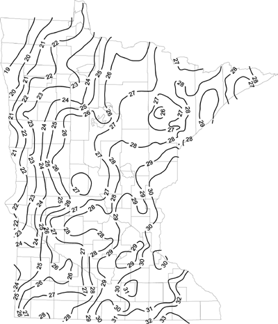
Figure 2.3 Average Annual Precipitation in Minnesota: 1961-1990. Courtesy of State Climatology Office, DNR-Waters Division, September, 1999.
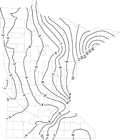
Figure 2.4 Annual Mean Runoff in Minnesota Measured in Inches: 1961-1990. Courtesy of State Climatology Office, DNR-Waters Division, September, 1999.
When precipitation reaches the earth it moves along one of three routes. It evaporates/ transpires back into the atmosphere, infiltrates the soil profile or runs across the earths surface into a body of water. According to the U.S. Geological Survey, about 78 percent (30 trillion gallons) of Minnesotas annual precipitation either evaporates or is transpired by natural vegetation (USGS, 1991). The remaining 22 percent of total precipitation (8 trillion gallons) either infiltrates the soil profile or runs off.
The topographical features and soil characteristics influence water storage capacity in the watershed. Forested watersheds with active wetlands can store substantial quantities of water and operate as a flood control mechanism by slowing and dampening peak flood impulse. In contrast, watersheds prone to flooding contain large areas of bare flat land that cannot store significant amounts of water.
Among the eight river basins in Minnesota, differences in the geomorphology of the flow pathways and water storage capacities in the watershed influence stream flows and the potential for flooding. The Rainy River and Lake Superior basins in northeastern Minnesota possess limited water storage capabilities because most tributaries flow over impermeable bedrock covered by only a thin layer of glacial drift. Despite limited storage capability of the soil profile, flows in the Rainy River basin remain relatively stable due to the substantial holding capacity of headwater lakes and wetlands. In contrast, very limited storage capacity in headwater areas in the Lake Superior basin makes these areas prone to flash flooding.
In the Red River basin, extensive areas of wetland, peat bogs, and marshes in northern tributary headwaters provide natural flood protection. However, the flat topography of the lower basin makes flooding a major problem in Red River valley. Spring flood waters can extend for miles, flowing over agricultural and municipal lands. Increased vulnerability of this area to floods stems from both stream channelization and draining of upland areas and prairie marshes. The most damaging floods on record occurred in 1950, 1966, 1979 and 1997. The 1979 flood resulted in property damage totaling $43.7 million. According to the 1998 Minnesota Recovery Disaster Task Force Anniversary Report, expenditures to remedy 1997 flood-induced damages totaled more than $830 million. Funding sources include $125 million from the state flood recovery fund, $573 million from the Federal flood recovery fund, and $132 million of private flood recovery funds.
The rivers of central Minnesota drain the Upper Mississippi basin. Natural regulation provided by extensive areas of lakes and swamps at the headwater areas contributes to stable stream flows. In addition, a series of headwater reservoirs regulates flows in the Upper Mississippi for navigational and other purposes. Flooding is a major problem along tributaries in the Lower Mississippi Basin of southeastern Minnesota. Spring snow melt and torrential summer thunderstorms may produce flash floods, a problem exacerbated by clearcutting on steep slopes for lumber and cattle grazing in the past.
In the Minnesota River Basin, which flows from west to east through the southern third of the state, stream flows have been modified greatly by human activities over the past 150 years. Over 90 percent of the land contained in the basin is under agricultural production. To support agricultural activities, the basin been extensively ditched, channelized, and drained by a vast network of drainage ditches and subsurface tiles.